Table of contents
Introduction
Glaciar de la Maladeta, June 18
Photo gallery
Aneto, June 19
Photo gallery
Summary and essentials
Introduction
The highest mountain in the Pyrenees, Pico d’Aneto (3404 meters AMSL) is one of those almost logical goals for someone who is enthusiastic about outdoor and mountaineering activities and loves visiting south-western Europe.
I was very lucky to have the opportunity to visit the Spanish Pyrenees for a second time in two years, this time during spring, so without further ado, let’s delve into it.
Glaciar de la Maladeta, June 18
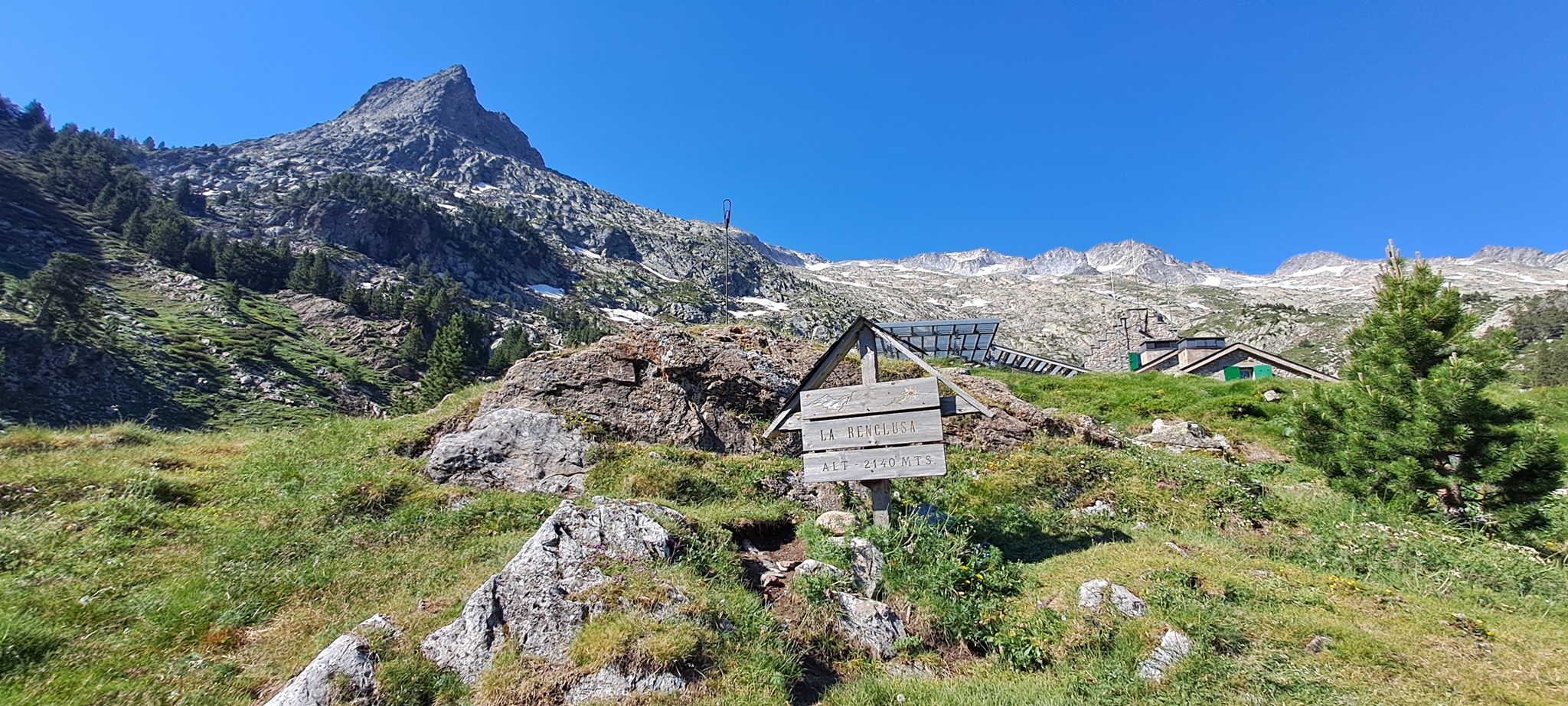
The usual starting point for summiting Aneto and other 3000 meter peaks in its proximity is the Refugio de la Renclusa (short La Renclusa) on 2140 meters.
Mid June is still early for going into the Pyrenees, access restrictions are not in place yet (they were in place beginning at Saturday, June 20, hence my timing was on point), so it was possible to park my car on the La Besurta parking lot (1900 meters). From there, it is an easy walk of thirty or so minutes to the Refugio.
It was already noon as I reached the refugio, for summiting Aneto obviously too late. However, a guy who worked in the refugio gave me the hint to visit Maladeta (I’d never heard about this mountain before), pointed it to me on a coarse map on the wall, and told me with a smile on his face for doing this there would be enough time left.
I was thinking about saving my energy for the next day, but on the other hand this would be a good opportunity to get a first impression of the area and the general conditions in higher altitudes, so I had no choice but to set off at once.
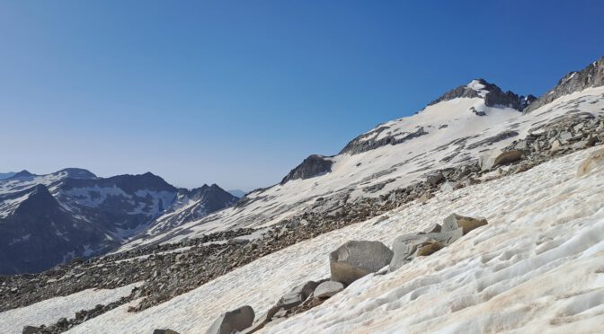
The snow and the first fringes of the “Glaciar de la Maladeta” started at some 2600 meters, after I had quite an easy hike of one hour through a blooming and very pretty landscape.
Finding a convenient and safe way across the glacier was challenging, I was zig-zagging and detouring a lot for there were barely any steps in the stained snow, let alone markings.
The Maladeta peak itself (3312 meters AMSL) I was not able to climb, but I did a little scrambling (desultory path finding that is) at the rocks lying unclad at the mountain foot, wondering in which category I can put this mountain in.
As a matter of fact, I learned later thru internet sources it is a mountain for more advanced climbers, what was evidently true, for I found old rope and other abandoned mountaineers’ equipment in several places.
The friendly guy at the refugio hadn’t suggested all that, what might have been a tribute to my self-assured demeanor (maybe he just rather pathetically assumed I had extensive experience since I wore my most ragged pair of trousers, and because I was a foreigner), so I had skipped the mandatory part doing my own inquiries what was of course a mistake.
An important note here: outside the refugio, that offers WiFi, you get virtually no cell service; and knowing some Spanish certainly does not hurt, people from Spain usually do not speak English (I also had no success with French) very well.
Rain and wind thwarted further attempts of mine to explore Maladeta, the suspicious clouds in the sky gave me finally an excuse for retreating to the refugio.
Photo gallery


Aneto, June 19
It is fair to say that Aneto is not a mountain for beginners either, technically easier than Maladeta for sure but the tour is much longer. If you belong to the quicker sort, you can do it in nine hours, but the usual time is something between ten to twelve hours (I needed ten and a half including breaks), starting and finishing point Refugio de la Renclusa.
Any mountain bearing the distinction being the highest you have to expect a good deal of visitors though, when weather is stable even more so.
So as opposed to the day before, there were always a handful of people around, only a short section to Portillón Superior I was alone. Because my orientation skills are not great, this was also the section where I had most trouble with path finding, others seem to be a lot better with this task (well, between you and me, I made an unintentional detour, that’s why I was alone).
The mountain saddle Portillón Superior (2899 meters AMSL, literal translation “Upper Small Gate”) is the first point where you can actually see Aneto, towering majestically in the distance.
This is also the point from where crampons are almost an obligation, so do yourself a favor and wear it. If you have an ice axe, even better. Furthermore, headgear and sunscreen is essential in these heights with snow reflecting the already fierce solar radiation.
I won’t bore you with text about the next two hours, it was just a tiring but otherwise not difficult walk across the glacier, and I suppose the pictures give a good enough impression of it.
The good news is that there’s plenty of water in liquid form (in spring anyway), so you do not have to carry very much.
When you’re already almost at the peak, you have to negotiate a unique obstacle, the “Bridge of Mohammed”. I made a video with my helmet camera, so I won’t bother with an elaborate text (or photos, for that matter) either, but I want to mention it is not a excessively long climb, five to ten minutes at most. You must not have fear of heights here.
Then it was done, standing on the highest peak of the Pyrenees, and it was marvelous.
Photo and video gallery
")


, right before \"Bridge of Mohammed\"")
")
")
")
")
")
")
Summary and essentials
Self-evidently, as Aneto is a popular peak, you have to make a reservation at the Refugio de la Renclusa a reasonable time in advance, and on weekends you can be certain it will get crowded in the area unless the weather’s really bad.
The difference in altitude is 1264 meters La Renclusa to Aneto, and the average hiker will need eleven-odd hours for ascent and descent, excluding breaks – most people start at six in the morning from La Renclusa. For the last section, the “Bridge of Mohammed”, you must not have fear of heights.
For the glacier(s) you need crampons and an ice axe, and the knowledge how to use them. Don’t let people tell you otherwise, I haven’t seen one single person without crampons during the entire day. Sun protection such as sun glasses and sun screen are absolute necessities too when being on snow and ice for extended periods of time.
Featured image: Pico d’Aneto towering in the distance